|
SRB
in the context of GCIP/GAPP objectives
|
The main objectives of
GAPP are:
 |
develop and demonstrate a capability to make reliable monthly
to seasonal predictions of precipitation and land-surface hydrologic
variables through improved understanding and representation
of land surface and related hydrometeorological and boundary
layer processes in climate prediction models; |
|
interpret and transfer
the results of improved seasonal predictions for the optimal
management of water resources;
The objective will
be achived, "if improvements are made
in the understanding of land surface, precipitation , radiation
and hydrologic processes over a continental domains at space
and time resolutions appropriate for future climate and related
hydrologic models" (GAPP Science Plan and Implementation Strategy,
2001).
|
|
|
Of particular interest
is the need to link radiative and hydrological processes. Satellites
provide the most realistic approach for obtaining radiative fluxes
on scales of interest in climate studies. NOAA/NESDIS is supporting
the GEWEX Continental-Scale Project (GCIP) and GEWEX Americas Prediction
Project (GAPP) activities by developing new operational products
from satellite observations. Shortwave radiative fluxes at the surface
and at the top of the atmosphere are part of this product. They
include both upwelling and downwelling shortwave fluxes, total and
diffuse, as well as spectral fluxes (e.g., the photosynthetically
active radiation (PAR), cloud amount and surface skin temperature.
Implementation of these products required development of a new configuration
of satellites data stream, and outputs from mesoscale numerical
weather prediction models. A brief summary of steps taken to reach
this stage will follow.
|
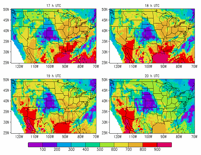
(Example of estimated surface downward flux (W/m**2), October 1, 1998)
SRB
implementation activity
|
In the framework
of a NOAA/NESDIS activity entitled: "Geostationary Satellite Products
for GEWEX Continental-Scale Project (GCIP)" directed by Dr. J. D. Tarpley from the NESDIS Satellite Research Laboratory, and supported
by the NOAA Climate and Global Change Research Program, an insolation algorithm
developed at the University of Maryland (Pinker and Laszlo, 1992)
has been transferred to NOAA/NESDIS for implementation with GOES-8 (Menzel
and Purdom, 1994). Changes in the algorithm to meet the specifications
of new sensors on board GOES-8, were implemented at the University of Maryland.
Developmental activity, in preparation for operational implementation at
NOAA, included the development of angular corrections as appropriate for
the filter functions of GOES-8 (Zhou et al., 1996). A new
interface between the 'raw' satellite observations and the inputs required
for the insolation model, were prepared at NOAA/NESDIS. The insolation
algorithm has been implemented on an hourly basis, for 0.5 degree targets
for an area bounded by 70-125 W longitude and 25-50 N latitude belts. For
each target, at appropriate forecast times, selected data from the NCEP
regional forecast ETA model (Black, 1994) have been delivered
to the satellite data stream, to serve as inputs to the insolation model.
They include snow cover and precipitable water. The assumption has been
that the input data as available from the ETA model will lead to improvements
in the satellite estimates of the surface and top of the atmosphere radiative
fluxes. In turn, the derived radiative fluxes can help to diagnose the
NCEP forecast model as to its ability to predict correctly radiative fluxes.
The evaluation of this new configuration included comparisons of the operational
version of the model with an off-line version, as well as evaluation against
ground truth, as available from independent projects, such as the Surface
Radiation Monitoring Network (SURFRAD) and other available networks.
|
Current
status
|
NOAA/NESDIS is
producing operationally shortwave (SW) surface and top of the atmosphere radiation
budget parameters, in support of the GEWEX Continental Scale International
Project (GCIP) (Leese,1994; 1997). The implementation activity by
NOAA is described in Tarpley et al. (1996). The model is driven
with GOES-8 satellite data as preprocessed at NOAA/NESDIS, and with auxiliary
information on the state of the atmosphere and the surface, as available
from the NOAA/NCEP ETA model, and from the Air Force snow analysis. Information
on wind speed, temperature, specific humidity at three levels at 50 mb
intervals, starting from the surface up, is also saved. At the University
of Maryland, the model can be run
in an off-line mode, with the same input data as used at NESDIS, and
the NOAA/NESDIS model outputs is stored. This allows to evaluate the performance
of the operational version of the model; to test possible improvements;
and to evaluate results against ground truth. About 20 stations are available
from the Illinois State Water Survey (Hollinger et al., 1994); about
twenty one stations are available from the Arizona Meteorological Network
(AZMET) (Brown, 1989); and four stations from the Surface Radiation
(SURFRAD) network (Hicks et al., 1995). These include stations in
Bondville, Ill., Fort Peck, Montana,Goodwin Creek, Missouri, and Table
Mountain, Colorado. Several locations have multiple sites. For instance,
at Bondville, Ill, both the Illinois State Water Survey and SURFRAD have
independent stations.
|
Calibration
issues
|
There is no visible
calibration source on board the satellite (Weinreb, 1997). The infrared
channel is calibrated in flight by taking data when the instrument is viewing
space and an on board calibration black body. The visible data are normalized.
This is a process of scaling the data in each visible channel to compensate
for differences in gain among the channels. Quality monitoring, generation
of visible normalization tables, and the archiving of calibration data
is done later off line at NOAA/NESDIS after the transmitted data are received.
It is planned that over the lifetime of each instrument, its calibration
trends will be monitored and improvements will be made. According to current
plans, a relative calibration, based on terrestrial targets, will be performed
routinely to correct for long term drift. As documented in "GOES-I-M
Product Assurance Plan", the NESDIS Physics Branch will assume responsibility
for the calibration. A calibration data base containing daily GOES- I-M
observations of approximately 50 terrestrial targets will be compiled.
The relative calibration technique that is currently in use for the AVHRR
Pathfinder Project will be applied.
|


|