|
Current Status
| In support of the GEWEX Continental Scale International Project
(GCIP) and GEWEX Americas Prediction Project (GAPP), NOAA/NESDIS has
been producing in real time, shortwave Surface Radiation Budget (SRB)
parameters since January 1996, using GOES-8 satellite observations.
The estimates are being made on an hourly basis for 0.5 degree targets
for an area bounded by 70-125 W longitude and 25-50 N latitude. This
product became operational in July 2000. |
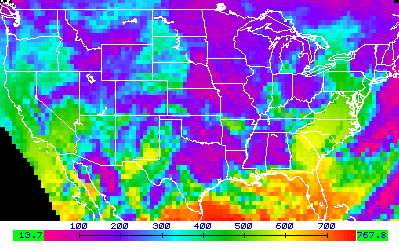
Example of surface downward flux estimated at 18:19 UTC
on 1 Dec 1997.
(Click here for an enlarged
version.)
| The NOAA/NESDIS product in a graphical format can be viewed at:
|
http://orbit-net.nesdis.noaa.gov/goes/gcip
| At the NOAA/NESDIS site, graphical information is kept for the latest
few days of operation. At the university of Maryland web site, several
SRB parameters from the NOAA/NESDIS product are provided almost in
real time as well as validation results.
For information on data that are currently provided go to Data
Access.
|
Methodology
| A modified version of the GEWEX SRB algorithm (Version 1.1), developed
at the University of Maryland, has been used. The model is driven
with GOES - 8 satellite data, as preprocessed at NOAA/NESDIS, and
auxiliary information on the state of the atmosphere, as available
from the NCEP Eta model. Information on the NCEP Eta model can be
found at: |
http://www.emc.ncep.noaa.gov:/mmb/gcip.html
| The implementation of the model requires satellite data preprocessing
and cloud screening, which are being performed at NESDIS under the
direction of Dr. J. D. Tarpley. Additional information required for
implementing the model is related to the state of the atmosphere and
the surface. Such information is extracted in real time from the NCEP
regional forecast model under the direction of Dr. K. Mitchell and
appended to the data stream. These include snow cover and precipitable
water. |
| Developmental activity, in preparation for the operational implementation
at NOAA, included the development of angular corrections as appropriate
for the filter functions of GOES-8 . The visible channel on the GOES-8
satellite is a narrowband channel. A study was undertaken to obtain
angularly dependent relationships between the broadband reflectance
and the narrowband reflectance, as observed from the visible channel
of GOES-8 (0.52- 0.72 um). Effects of surface properties, aerosols,
clouds and sun-viewing geometry are taken into account. The relationships
were developed based on simulations of filtered visible channel reflectance
of GOES-8 and unfiltered broadband reflectance. An angularly dependent
atmospheric radiation model (LOWTRAN 7) was used for simulations.
Results are calculated for a wide range of relative azimuth angles
and satellite zenith angles, in conjunction with various surface types,
such as ocean, vegetated land, desert, and snow. Several cloud types,
such as stratus, altostratus, stratocumulus and cirrus, are also included
in the simulations. Conditions with different loading of aerosols
are simulated separately, to analyze aerosol sensitivity of the relationships.
Experiments are in progress on the need to perform operationally angularly
dependent transformations. In the current version of the SRB model
as implemented by NESDIS, only one transformation, based on the ensemble
of simulations, is in use. |
| Details about the algorithm can be found in Pinker and Laszlo (1992).
|
Parameters produced
at NOAA/NESDIS
Activities in progress at the University of
Maryland
- An archive of the NOAA/NESDIS input and output data is being
kept at the Department of Meteorology, University of Maryland.
- At the University of Maryland, the shortwave SRB algorithm,
as implemented at NOAA/NESDIS is evaluated by comparing operational
products with results obtained off-line, using the same input
data as generated by NOAA/NESDIS.
- Model results are evaluated against ground truth. Data from
about fifty stations are in use in the validation effort. Locations
of ground stations used in the validation, as well as results
are presented in Validation.
- Model improvement activity.
Acknowledgement
This activity is supported by the NOAA Climate and Global Change
Program, Office of Global
Programs, United States Department of Commerce, National Oceanic
and Atmospheric Administration , 1100 Wayne Avenue, Suite 1225 Silver
Spring, Maryland 20910 and by the NASA Land Surface Hydrology program,
Office of Earth Science,
NASA Headquarters, Washington DC, 20546.
|

|
Personnel involved in the project - Contacts.
|


|
