A retrospective analysis of the global ocean 1950-1995 and its comparison to observations
James A. Carton, Gennady Chepurin, and Xianhe Cao
January 5, 1998
Submitted to Journal of Physical Oceanography
Department of Meteorology,
University of Maryland, College
Park, MD 20742
Abstract
We explore the accuracy of a comprehensive
46-year retrospective analysis of upper ocean temperature, salinity, and
currents. The Simple Ocean Data Assimilation (SODA) analysis is global,
spanning the latitude range ![]() .
The SODA analysis has been constructed using suboptimal estimation techniques
combining numerical model forecasts with temperature and salinity profiles
(MBT, XBT, CTD, and station), sea surface temperature, and altimeter sea
level. To determine the accuracy of the analysis we conduct a series of
comparisons to independent observations at interannual and longer time-scales.
.
The SODA analysis has been constructed using suboptimal estimation techniques
combining numerical model forecasts with temperature and salinity profiles
(MBT, XBT, CTD, and station), sea surface temperature, and altimeter sea
level. To determine the accuracy of the analysis we conduct a series of
comparisons to independent observations at interannual and longer time-scales.
We begin by exploring the temporal variability of the analysis by comparison to tide gauge sea level records and the ocean weather station S temperature and salinity time series. The comparisons show that 1/4 to 1/3 of the variance of the sea level time series is explained by the analysis. Part of the variance which is not explained is due to unresolved mesoscale phenomena. Also important are errors in the rate of water mass formation and the limited number of direct observations of salinity. We next explore the spatial variability of the analysis. Comparisons are presented to altimeter sea level, WOCE global hydrographic sections, and surface drifter velocity. The results of these comparisons are quite encouraging. However, our attention is focused mainly on the differences between the observations and the analysis. The differences are largest in the eddy production regions of the western boundary currents and the Circumpolar Current. Differences are generally smaller in the tropics, although the major equatorial currents are too broad and weak.
Recently we have reported a new retrospective analysis of upper ocean temperature, salinity, and currents for the global ocean, 1950-1995 (Carton et al. 1998). The result of that research has been to provide a synthesis of the historical oceanographic data record in the form of a retrospective analysis. Here we describe the results of an exploration of the accuracy of this analysis.
The Simple Ocean Data Assimilation (SODA) algorithm used to construct our retrospective analysis consists of a numerical forecast model and an update algorithm to provide corrections to the forecast. The update algorithm is based on a technique widely applied in atmospheric numerical weather prediction called optimal interpolation (see, Daley, 1991). In optimal interpolation the differences between observed variables such as temperature, salinity, and sea level and model forecasts of the same variables are used to update the forecast. The interpolation coefficients, otherwise known as gain matrices are determined so as to minimize the mean square error of the analysis. Our implementation of this algorithm differs from the usual implementation because of our inclusion of spatial dependence of the assumed error statistics, and because of our assumptions about bias in the model forecast.
In our implementation of optimal interpolation updates to the model forecast are calculated every 10 days. Then in a second integration the forecast is corrected continuously using the technique of incremental analysis updates (Bloom, 1996). This technique reduces the generation of spurious waves by correcting the forecast gradually. It has a second advantage of reducing the effects of model bias. The effects of model bias may be further reduced by explicitly including an analysis of bias along with an analysis of the state of the ocean (Dee and da Silva, 1997).
SODA differs from the more sophisticated, but much more computationally intensive Kalman Filter only to the extent that we do not have prediction equations for the temporal and spatial evolution of the error statistics. Rather, the error statistics are determined a priori based on a statistical analysis of errors from a preliminary analysis. Our approach also bears close similarity to variational assimilation methods when the mean square error is minimized such as that described in Ji et al. (1995). Indeed, comparison of the results from the analysis presented here with those of Ji et al. show correlations of heat content exceeding 90% in the tropical Pacific during the 13-year period when the latter is available. Comprehensive discussions of the alternatives in formulating updating algorithms is provided by Bennett (1990) and Wunsch (1996). Review of many current implementations is given in Malonote-Rizzoli (1996).
The general circulation ocean model on
which our analysis is based uses the full Geophysical Fluid Dynamics Laboratory
Modular Ocean Model 2.b primitive equation code, with conventional choices
for mixing, etc. The domain of this analysis is global, extending from
![]() to
to ![]() .
The model horizontal resolution is
.
The model horizontal resolution is ![]() in
the tropics, expanding to a uniform
in
the tropics, expanding to a uniform ![]() resolution
at midlatitude. No attempt is made to resolve midlatitude eddy processes.
At the polar boundaries the temperature and salinity fields are relaxed
to climatology. We make no attempt to model cryospheric or deepwater formation
processes explicitly. A weak 5-year relaxation of the global temperature
and salinity fields is included in order to reduce forecast bias in deep
water masses. Bottom topography is included. The model has 20 levels in
the vertical, with 15m resolution in the upper 150m. The time step is 1
hr. In this model sea level is obtained through diagnostic calculation
from the mass and momentum fields. Winds are provided by an analysis of
historical shipboard measurements by da Silva
et al. (1994) prior to 1993 and by the National Center for Environmental
Prediction after that date.
resolution
at midlatitude. No attempt is made to resolve midlatitude eddy processes.
At the polar boundaries the temperature and salinity fields are relaxed
to climatology. We make no attempt to model cryospheric or deepwater formation
processes explicitly. A weak 5-year relaxation of the global temperature
and salinity fields is included in order to reduce forecast bias in deep
water masses. Bottom topography is included. The model has 20 levels in
the vertical, with 15m resolution in the upper 150m. The time step is 1
hr. In this model sea level is obtained through diagnostic calculation
from the mass and momentum fields. Winds are provided by an analysis of
historical shipboard measurements by da Silva
et al. (1994) prior to 1993 and by the National Center for Environmental
Prediction after that date.
The main data sets to constrain the model forecast are the hydrographic data contained in the World Ocean Atlas 1994 (WOA-94, Levitus et al., 1994), additional hydrography obtained from a variety of sources, sea surface temperature (Reynolds and Smith, 1994), and altimetry from the Geosat, ERS1, and TOPEX/Poseidon satellites. The hydrographic data set exceeds 50,000 profiles per year for much of our 46-year period of interest. This data set has been collected using several different instruments. In the interval 1950 to 1969 most of the temperature measurements were made with the mechanical bathythermograph. This subset reached a maximum 70,000 measurements per year in 1968, but is limited to sampling temperature in the upper 200m. After 1969 the mechanical bathythermograph was replaced by the expendable bathythermograph. Two other small subsets, conductivity-temperature-depth and bottle measurements, are important because they provide salinity as well as temperature, and because they extend more deeply into the water column.
The altimeter sea level used here is based
on the NASA Pathfinder Project version 2.1 to which we have added all the
standard corrections for geophysical effects, and then averaged along-track
into ![]() bins. No other interpolation
was carried out. The altimeter data comes from four instruments, GEOSAT,
ERS1, and the TOPEX/Poseidon altimeters. The altimeter data set begins
in November, 1986 with the GEOSAT Exact Repeat Mission. No altimeter data
is available from the end of the Geosat mission in the fall of 1989 until
the beginning of ERS1 in the spring of 1992.
bins. No other interpolation
was carried out. The altimeter data comes from four instruments, GEOSAT,
ERS1, and the TOPEX/Poseidon altimeters. The altimeter data set begins
in November, 1986 with the GEOSAT Exact Repeat Mission. No altimeter data
is available from the end of the Geosat mission in the fall of 1989 until
the beginning of ERS1 in the spring of 1992.
In addition to the basic analysis, which we refer to as the control analysis, a series of experiments (see Table 1) have been carried out to determine some of the properties and sensitivities of the analysis. The control analysis and analysis experiments begin January, 1950 and continue through December, 1995. The analysis fields for each experiment consist of 552 monthly averages of temperature, salinity, and the horizontal components of velocity at 20 levels. Comparison of the experiments reveals important sensitivities of the analysis to changes in parameters, boundary conditions, etc. Some review of these results is provided in this paper. A more extensive discussion is provided in Carton et al. (1998).
Table 1. Ocean analysis experiments presented in the text. Each experiment covers the period 1950-1996. Further description of these experiments is provided in Carton et al. (1998).
Here our examination of analysis error focuses on comparison to independent observations on interannual and longer time-scales. We limit our comparison to examination of correlations and root-mean-square (RMS) differences and a more detailed examination of one example. Section 2 examines the temporal variability of the analysis. We begin with a comparison to tide gauge sea level time series chosen from among those records maintained at the Permanent Service for Mean Sea Level. Low frequency errors in sea level generally reflect the vertical integral of temperature and salinity errors. We next examine the vertical structure of these errors by comparing the analysis to an ocean weather station temperature and salinity time series. The most interesting time series is that at station S near Bermuda in the subtropical gyre of the North Atlantic. The comparison at S allows us to explore the rate of subtropical mode water production in the analysis.
In Section 3 our examination focuses on the spatial structure of analysis error. Data sets with good spatial coverage include altimeter sea level, global hydrographic sections, and surface drifter velocity. We begin by comparing a subset of observed sea level with sea level from an experimental analysis in which observed sea level is not assimilated. This comparison shows that the largest errors are associated with eddy-generation regions. We then examine the horizontal and vertical structure of temperature and salinity error using independent transects collected as part of the World Ocean Circulation Experiment (WOCE). This comparison shows the contribution of errors in surface heat and freshwater flux, and errors in subduction processes, as well as the contribution of mesoscale variability. Finally, we examine errors in surface velocity by comparison to surface drifter velocity records and moored currents.
In this section we present a comparison to island tide gauge records and to the ocean weather station S time series of temperature and salinity at Bermuda. These data sets allow a detailed examination of the accuracy of the analysis at interannual to decadal periods. The behavior of the analysis at short seasonal periods is discussed elsewhere (Carton et al., 1998).
Tide gauge comparison
Approximately 1800 tide gauge records are
available from the Permanent Service for Mean Sea Level or the Tropical
Ocean/Global Atmosphere sea level archives. However, many gauges are in
locations which are unsuitable for observing the large-scale circulation,
while others have records that are too short for our purposes. After examining
the data sets we have identified 20 stations, mainly from islands in the
North Atlantic and Pacific (in the latitude band ![]() ),
with records that each exceed 17 years in length and do not seem excessively
gappy or otherwise contaminated.
),
with records that each exceed 17 years in length and do not seem excessively
gappy or otherwise contaminated.
At each of the station locations we have
carried out a comparison between annually averaged observations and control
analysis sea level time series. The comparison is summarized in Table
2. Correlations between observed and control analysis sea level
is presented as Cor1. The lowest correlations are for continental stations
such as La Coruna, Spain and for some of the subtropical and midlatitude
islands such as the Canary Islands. The agreement at islands in the tropical
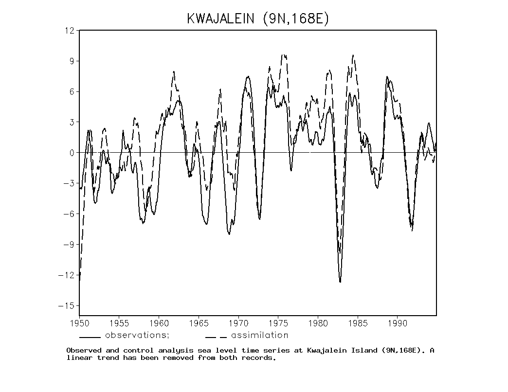
Pacific such as Kwajalein (![]() ,
Fig. 1) is generally excellent. A
succession of high and low sea level events in the record at Kwajalein
reflect the importance of El
,
Fig. 1) is generally excellent. A
succession of high and low sea level events in the record at Kwajalein
reflect the importance of El ![]() /
Southern Oscillation throughout the tropical Pacific. The earliest strong
event in this record is the
/
Southern Oscillation throughout the tropical Pacific. The earliest strong
event in this record is the ![]() of
1957-8 which is indicated by a rise in sea level followed by a 9 cm drop.
The strongest event overall is the 1982-3
of
1957-8 which is indicated by a rise in sea level followed by a 9 cm drop.
The strongest event overall is the 1982-3 ![]() when
sea level dropped by 20 cm. The differences between observed and analysis
sea level appear to be of longer than interannual time-scale. We examine
the decadal behavior of these records below. Interestingly, the anomaly
correlations in Table 2 are quite comparable
to correlations reported previously by Miller
and Cane (1996) for much shorter 2-year intervals that also included
the seasonal cycle.
when
sea level dropped by 20 cm. The differences between observed and analysis
sea level appear to be of longer than interannual time-scale. We examine
the decadal behavior of these records below. Interestingly, the anomaly
correlations in Table 2 are quite comparable
to correlations reported previously by Miller
and Cane (1996) for much shorter 2-year intervals that also included
the seasonal cycle.
Table 2 Statistical comparison of control analysis and tide gauge sea level for selected stations. Record length is given, along with overall correlation (COR1) and correlation of 5yr low-pass filtered records (COR2).
| NAME |
LOCATION |
YRS | COR1 | COR2 |
| Atlantic | ||||
| San Juan (Puerto Rico) | 26 | 0.50* | 0.34 | |
| Tenerife (Canary Is.) | 38 | -0.02 | -0.21 | |
| Bermuda, Is. | 40 | 0.46* | 0.72* | |
| La Coruna (Spain) | 27 | 0.28 | 0.31 | |
| Pacific | ||||
| Rikitea Is. | 20 | 0.15 | 0.43 | |
| Noumea II | 22 | 0.52* | 0.77* | |
| PagoPago Is. | 40 | 0.34* | 0.56* | |
| Christmas Is.*(2 parts) | 14 | 0.86* | 0.88* | |
| Pahnpei-b Is. | 17 | 0.86* | 0.71* | |
| Majuro-b Is. | 17 | 0.79* | 0.81* | |
| Kwajalein Is. | 45 | 0.73* | 0.74* | |
| Yap Is. | 21 | 0.66* | 0.91* | |
| Guam Is. | 41 | 0.70* | 0.45* | |
| Johnston Is. | 41 | 0.66* | 0.40* | |
| Wake Is. | 38 | 0.54* | 0.67* | |
| Hilo, Hawaii | 45 | 0.44* | 0.35* | |
| Honolulu, Hawaii | 45 | 0.67* | 0.70* | |
| French Frigate Shoals | 17 | 0.44 | 0.77* | |
| Midway Is. | 35 | 0.07 | 0.44* | |
| Sitka, Alaska | 35 | 0.07 | 0.44* |
Christmas Island Record comes in two parts each as been detrended. The comparison is with the combined record. Correlations marked * exceed the 95% test of significance.
The success of this analysis in describing interannual variability in the tropical Pacific leaves open the question of whether information about interannual variability is contained primarily in the historical winds entering the analysis through the model forecast or subsurface temperature data entering the analysis through the updating procedure. Examination of Expt.s 2 and 3 reported in Carton et al. (1998) show that both the forecast and the updating contribute.
In order to determine the quality of the comparison at frequencies longer than interannual we next filter all time series with a 5-year low pass filter. A linear trend is also removed in order to eliminate unmodeled geophysical effects such as geologic uplift and global sea level rise due to continental ice melt. The resulting gauge comparisons are labeled Cor2 in Table 2. In two-thirds of the stations in the tropical Pacific the correlation of observed and analysis sea level is improved by low-pass filtering. In mid- and high latitude the correlation also improves, but generally remains below 0.5. The arithmetic averages correlation of the two sets of records are 0.48 and 0.56. If these values are representative they would suggest that the control analysis explains 23% of the sea level variance, increasing to 31% on time scales between 5 and 25 years. A significant fraction of the unexplained variance is due to mesoscale processes which cannot be resolved by our analysis and is of less interest to us (the contribution of mesoscale variability is evident in the comparison of the Honolulu and Hilo time series).
The three pairs of low-pass filtered time series shown in Fig. 2 include one (San Juan) which has a correlation of less than 0.5 and two (Honolulu and Kwajalein) which exceed 0.7. At all three stations a visual comparison reveals substantial similarity. The main differences at San Juan seem to be in the specific timing of the anomalies rather than their amplitude or duration. At Honolulu the major differences between observed and analysis sea level occur prior to 1960, when the subsurface data coverage was less complete.
Ocean Station S temperature and salinity
Thirteen permanent ocean weather stations
were established in the North Atlantic and Pacific following World War
II by the United Nations (Dinsmore, 1996).
Most of the stations maintained by the United States were terminated by
1977 so that their record lengths are short. Others are too far north to
be of interest to us. However, ocean weather station S in the western
side of the Atlantic subtropical gyre (![]() ),
is well suited for use in examining the properties of the analysis. In
order to make the comparison at this station independent the station S
hydrographic data, a combination of bottle data and CTDs, has been specifically
excluded from the control analysis and the experiments.
),
is well suited for use in examining the properties of the analysis. In
order to make the comparison at this station independent the station S
hydrographic data, a combination of bottle data and CTDs, has been specifically
excluded from the control analysis and the experiments.
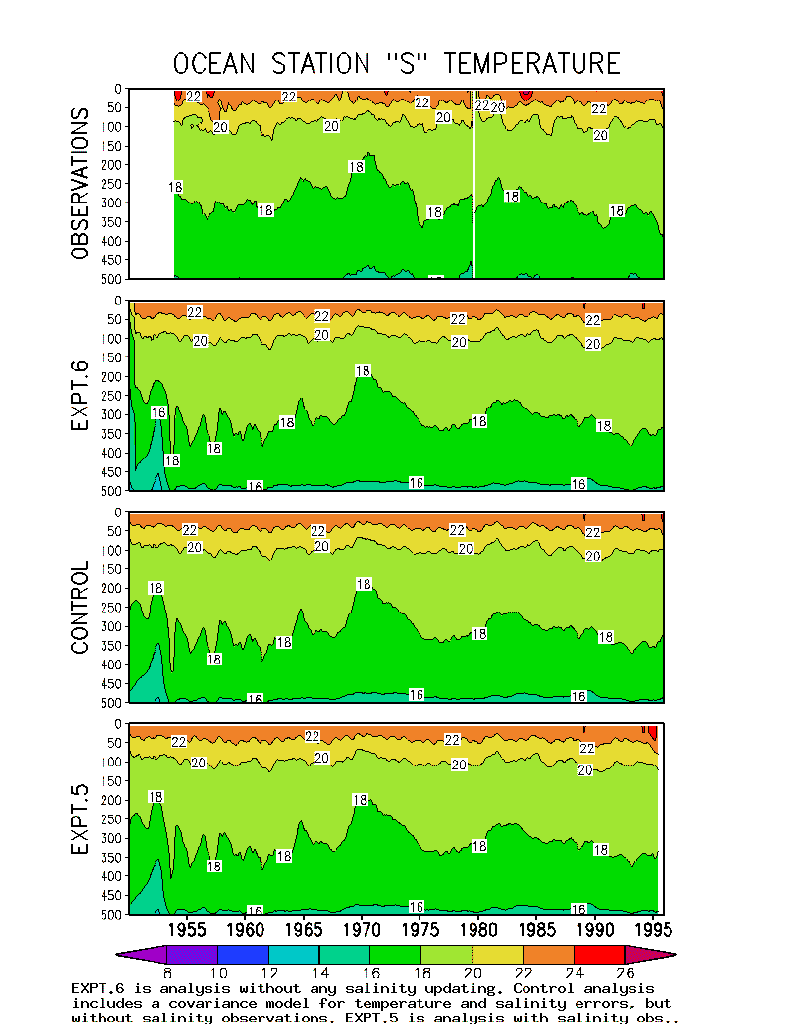
The observed mixed layer at S is
shallow, less than 25m deep, throughout the summer. By late winter this
layer deepens to 200m or more with mixed layer temperatures decreasing
to ![]() (Michaels
and Knap, 1996). Within this mixed layer temperature and salinity
are largely independent. Fig. 3a,b,
upper panels show that from year to year the mixed layer temperature and
salinity at this location vary independently of each other. Joyce
and Robbins (1996) observe that mixed layer salinity has
a longer time-scale than temperature. They conclude that salinity is more
closely coupled to the slowly varying properties of the water mass below
the mixed layer, while temperature is more closely linked to surface meteorology.
(Michaels
and Knap, 1996). Within this mixed layer temperature and salinity
are largely independent. Fig. 3a,b,
upper panels show that from year to year the mixed layer temperature and
salinity at this location vary independently of each other. Joyce
and Robbins (1996) observe that mixed layer salinity has
a longer time-scale than temperature. They conclude that salinity is more
closely coupled to the slowly varying properties of the water mass below
the mixed layer, while temperature is more closely linked to surface meteorology.
Much of our interest in the time series
at ocean weather station S is in the properties of this water mass.
The distinctive subtropical mode water mass is characterized by a uniform
temperature with depth, or thermostaad, of nearly ![]() .
It is present in a layer approximately 200m thick throughout the Sargasso
Sea, but is formed in a more limited region to the northeast of Bermuda
in late winter. Changes in the thickness of the
.
It is present in a layer approximately 200m thick throughout the Sargasso
Sea, but is formed in a more limited region to the northeast of Bermuda
in late winter. Changes in the thickness of the ![]() thermostaad at Bermuda are thought to indicate changes in the rate of water
mass formation.
thermostaad at Bermuda are thought to indicate changes in the rate of water
mass formation.
The early part of the record at S
has been examined by Talley and Raymer (1983)
from this prospective. They argue that ![]() water
mass formation ceased during 1972-1975 leading to lower temperature and
salinity (this is apparent in the depth of the
water
mass formation ceased during 1972-1975 leading to lower temperature and
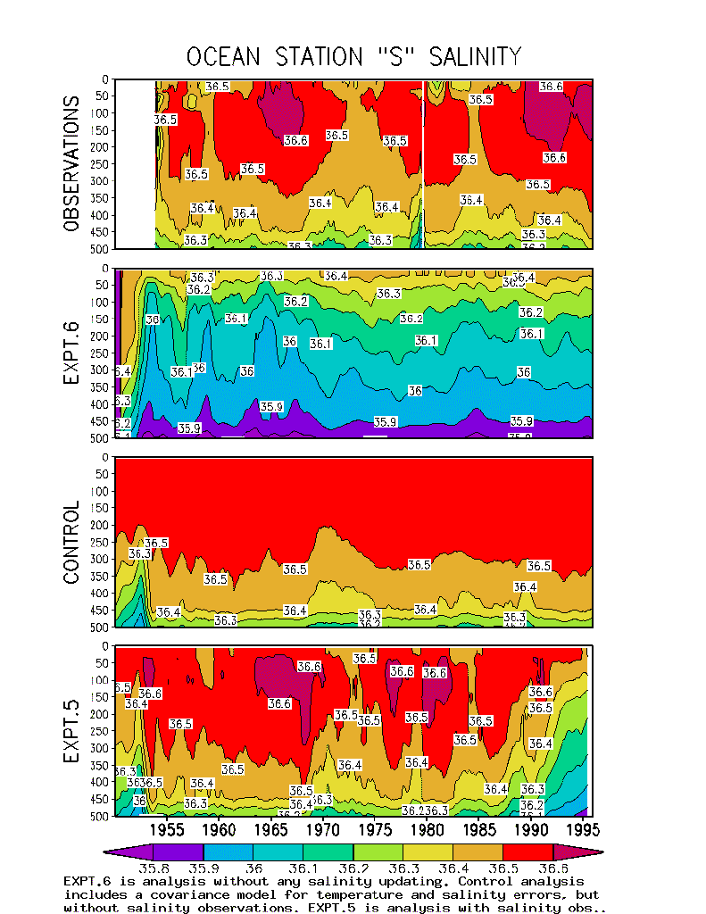
salinity (this is apparent in the depth of the ![]() isotherm in Fig. 3a, upper panel
and the 36.5 psu contour in Fig. 3b,
upper panel). The spatial structure of this event in the early 1970s was
examined by Levitus (1990) who showed
that the changes extended throughout the subtropical gyre. A second, less
dramatic change in water mass formation apparently occurred in 1984-5.
isotherm in Fig. 3a, upper panel
and the 36.5 psu contour in Fig. 3b,
upper panel). The spatial structure of this event in the early 1970s was
examined by Levitus (1990) who showed
that the changes extended throughout the subtropical gyre. A second, less
dramatic change in water mass formation apparently occurred in 1984-5.
Below the layer containing subtropical mode water are the thermocline and halocline whose 50m vertical (or 300 km horizontal) excursions are highly correlated with sea level (Roemmich, 1990).
Cooper and Haines (1996) has been recently pointed out the need to maintain consistency between temperature and salinity. In the remainder of Fig.3a,b we explore this issue by presenting vertical cross-sections of temperature and salinity from the control analysis and two experiments. In Expt. 6 the analysis is carried out without any constraint on the salinity field, except a weak relaxation to climatology. Although the reconstruction of the temperature field is good, the analysis is unable to reproduce the observed subsurface salinity maximum. Indeed, the upper water column becomes too fresh by up to 0.5 psu. In the control analysis where salinity errors are updated based on observed temperature errors the water column is no longer too fresh. In addition, the salinity anomalies of 1972-4 and 1984-5 are now evident below the mixed layer, but are much weaker than observed. The mixed layer has no salinity anomalies since temperature and salinity errors are not correlated in the mixed layer. In Expt. 5 when direct observations of salinity are assimilated (except the observations at S) the salinity becomes the most realistic of all. The main errors are before 1953 due to initialization transients, and after 1990 (the last date of salinity measurements in the WOA-94 data set).
In all three of the analyses shown in Fig.
3a,b
the temperature field at S is well-represented. However, in the
absence of subsurface temperature updating (Expt.
2) the ![]() thermostaad disappears
by 1960. The disappearance of the
thermostaad disappears
by 1960. The disappearance of the ![]() water
indicates that the model is unable to form subtropical water properly in
the absence of data assimilation. A number of possible causes of this problem
have been suggested to the authors including causes resulting from limited
model resolution, and causes associated with insufficient mixed layer density
anomalies such as the absence of strong cold air outbreaks in the historical
surface forcing fields and insufficient mixed layer salinity variability.
Insufficient
water
indicates that the model is unable to form subtropical water properly in
the absence of data assimilation. A number of possible causes of this problem
have been suggested to the authors including causes resulting from limited
model resolution, and causes associated with insufficient mixed layer density
anomalies such as the absence of strong cold air outbreaks in the historical
surface forcing fields and insufficient mixed layer salinity variability.
Insufficient ![]() water production
in the forecast model is a problem that needs further exploration.
water production
in the forecast model is a problem that needs further exploration.
The comparisons reported in this section involve data sets with more limited temporal coverage, but with expanded spatial coverage (altimeter sea level, WOCE hydrography, surface drifters and moored currents).
Altimeter sea level
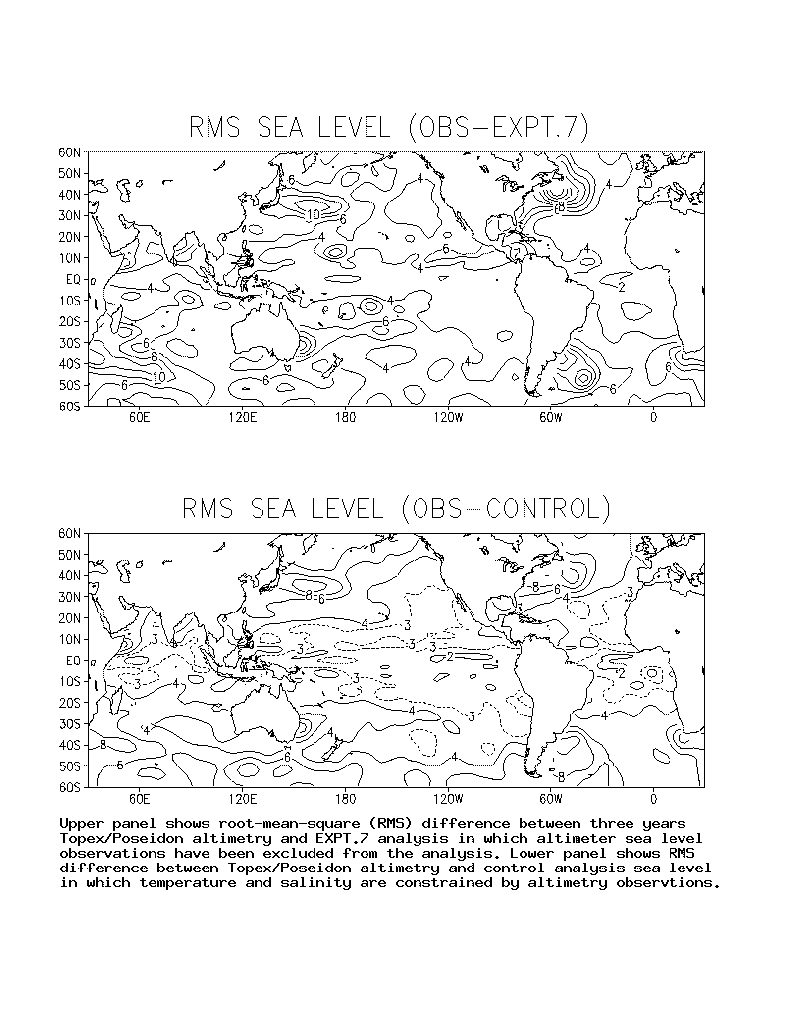
Although the time series comparisons discussed above provide information about interannual to decadal variability, they have limited spatial coverage and have only indirect information about currents. The availability in recent years of satellite altimeter sea level offers us the opportunity to examine the accuracy of the analysis essentially globally. In order to make the comparison to altimeter sea level independent we introduce a new experiment, Expt. 7, in which altimeter sea level information has been excluded from the updating procedure. We limit our discussion here to consider only the Topex/Poseidon altimetry because its low observation error.
The error in observed monthly-averaged
Topex/Poseidon altimeter sea level has been estimated to be in the neighborhood
of 2cm in the tropical Pacific (Cheney, et
al, 1994; Mitchum, 1994).
The RMS difference between observed and Expt.
7 sea level exceeds the observation error by 2-4 cm (Fig.
4a). The difference is lowest in the tropics, and somewhat lower
on the eastern side of the basin than the western side of the basin. In
the eastern tropical basin the RMS difference drops below 3 cm. For the
whole tropical belt ![]() the RMS
difference is around 4.0 cm.
the RMS
difference is around 4.0 cm.
The RMS difference increases in regions
of high eddy generation such as the regions of western boundary current
extensions and in the Circumpolar Current. A few "bull's-eyes"
appear in Fig. 4a. Close examination
shows that these result from miss-located XBTs which are then inconsistent
with altimeter sea level. One example of a miss-located XBT is at ![]() ,
,
![]() in Fig.
4a. The RMS difference for the full
in Fig.
4a. The RMS difference for the full ![]() domain
is 5.2 cm.
domain
is 5.2 cm.
When altimeter sea level is used as a constraint
on the analysis temperature and salinity fields (but not pressure since
pressure is not a prognostic model variable), the RMS difference is reduced
by 1-2 cm (Fig. 4b). In the
tropical Atlantic and Pacific the differences lie in the range 2-3 cm.
The average for the full tropical belt ![]() becomes
3.1 cm. In the mesoscale eddy production regions of the midlatitudes the
RMS difference again increases due to limitations in model physics and
poorer error statistics.
becomes
3.1 cm. In the mesoscale eddy production regions of the midlatitudes the
RMS difference again increases due to limitations in model physics and
poorer error statistics.
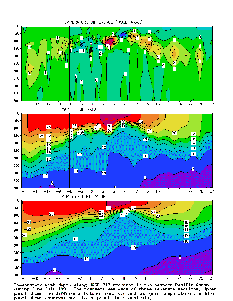
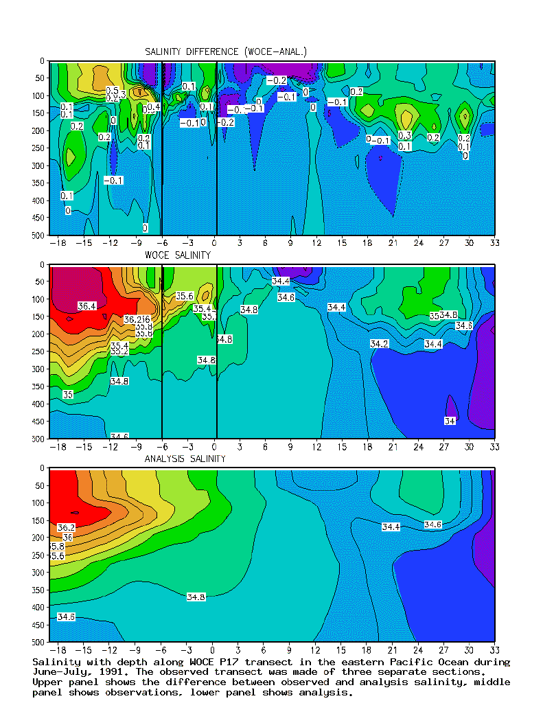
WOCE hydrographic transects
The World Ocean Circulation Experiment is an international program designed to define the large-scale structure of the ocean. The field program, including a broad array of observations, has been concentrated on the period since 1989. A primary data set consists of a series of high quality one-time hydrographic surveys transecting the major oceans with some repeat sections. With the exceptions noted below this data set was not included in the data archive of Levitus et al. (1994) and consequently provides us with wonderful independent data for comparison.
Not all of the WOCE hydrography is publicly available. From the more limited set of data available from the WOCE Special Analysis Center at Scripps Institution of Oceanography, we have extracted 16 transects listed in Table 3. The temperature and salinity data along each transect has been linearly interpolated on constant depth surfaces to the model grid coordinates and then compared to the monthly-averaged temperature and salinity fields from the control analysis. Along each section the RMS difference between observed and control analysis temperature and salinity has been computed at the model levels and averaged in depth and distance along the cross-section. In some cases the transects have been decomposed into smaller sections when they span more than a single month.
Table 3 Root-mean-square differences between observed and control analysis temperature and salinity along WOCE hydrographic sections
*Temperature (but not salinity) from these cruises has been assimilated in the control analysis.
The large error in temperature for A11 can be understood because of its location in the poorly sampled Southern Hemisphere and the high degree of eddy variability. The errors for PR3 in the subtropical North Pacific and PR16 in the tropical Pacific are more surprising. The transects with large salinity errors generally have two kinds of errors. Either the salinity errors are large in the mixed layer (PR3, AR15, AR4E) indicating problems with surface fluxes or they are confined below the mixed layer. Two of the transects with substantial salinity errors below the mixed layer (P1, PR13J) do not have large corresponding errors in temperature suggesting that the salinity errors are the result of errors in horizontal advection.
One particularly interesting transect is
one labeled P17 which cuts through the eastern
Pacific from ![]() to
to ![]() .
This transect was completed in several segments which are separated by
vertical lines in Fig. 5a,b.
At subtropical latitudes comparison of observed and analysis temperature
fields shows that the most significant error is at thermocline depths.
Analysis temperature is too low by
.
This transect was completed in several segments which are separated by
vertical lines in Fig. 5a,b.
At subtropical latitudes comparison of observed and analysis temperature
fields shows that the most significant error is at thermocline depths.
Analysis temperature is too low by ![]() suggesting that the thermocline is too shallow by 10-20 m. The largest
error is between
suggesting that the thermocline is too shallow by 10-20 m. The largest
error is between ![]() and
and ![]() .
This band of latitudes corresponds to the North Equatorial Countercurrent
trough which separates the northern extension of the South Equatorial Current
from the North Equatorial Countercurrent. Weakness in the trough implies
that the transports in these two currents are weak.
.
This band of latitudes corresponds to the North Equatorial Countercurrent
trough which separates the northern extension of the South Equatorial Current
from the North Equatorial Countercurrent. Weakness in the trough implies
that the transports in these two currents are weak.
Comparison of observed and analysis salinity
fields also shows that significant error is present at thermocline depths
as well as in the mixed layer (Fig.
5b). South of the equator the observed transect shows evidence
of subduction and equatorward transport of high salinity subtropical water.
The observed salinity maximum is narrowly confined in depth within a few
degrees of the equator. In contrast, the analysis salinity shows a broader,
weaker subsurface salinity maximum. This difference indicates that the
analysis is subducting subtropical water, but not as rapidly as is observed.
One factor may be that the mixed layer salinity reaches a maximum of 36.2
psu, 0.2 psu lower than observed. In contrast, the analysis mixed layer
salinity between ![]() and
and ![]() is
more than 0.2 psu higher than observed. In summary, the major sources of
error include those associated with errors in the mixed layer and subduction
processes, large-scale bias, and unresolved mesoscale variability.
is
more than 0.2 psu higher than observed. In summary, the major sources of
error include those associated with errors in the mixed layer and subduction
processes, large-scale bias, and unresolved mesoscale variability.
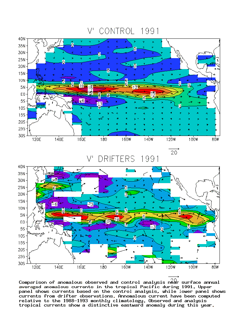
Surface drifters
The most extensive spatial coverage of
velocity measurements is provided by the WOCE/TOGA surface drifter velocity
program (Niiler, et al, 1997). Although
some measurements were collected in the early 1980s, extensive coverage
is only available since 1988. We have obtained the data presented here
from the Atlantic Oceanographic Marine Laboratory/NOAA, where the drifter
data has been converted to Eulerian velocities and averaged into ![]() bins. We compute velocity anomalies by removing the 1988-1993 monthly climatology
from the observations and analyses. Table 4
shows the spatial average of the RMS velocity anomaly components, as well
as the RMS differences between observed and analysis anomalous velocity
components for each year. We approach this comparison with trepidation
since near-surface velocity is a difficult field to simulate. The six-year
averages show that the RMS anomalous zonal velocity difference (13.3 cm/s)
is 30 % less than the RMS zonal velocity itself (20.6 cm/s). Some similarity
in observed and analysis variability is present in almost every year in
both zonal and meridional components.
bins. We compute velocity anomalies by removing the 1988-1993 monthly climatology
from the observations and analyses. Table 4
shows the spatial average of the RMS velocity anomaly components, as well
as the RMS differences between observed and analysis anomalous velocity
components for each year. We approach this comparison with trepidation
since near-surface velocity is a difficult field to simulate. The six-year
averages show that the RMS anomalous zonal velocity difference (13.3 cm/s)
is 30 % less than the RMS zonal velocity itself (20.6 cm/s). Some similarity
in observed and analysis variability is present in almost every year in
both zonal and meridional components.
Table 4. RMS near-surface
anomalous observed velocity components and RMS differences between anomalous
observed and analysis velocity components. Zonal and meridional anomalous
velocity components are computed with respect to the 1988-1993 monthly
climatology and averaged over the Pacific basin between ![]() .
.
| YEAR | RMS (u') | RMS(v') | |||
| 1988 | 25.4 cm/s | 15.2 cm/s | 16.7 cm/s | 11.3 cm/s | |
| 1989 | 20.4 | 13.3 | 17.0 | 10.1 | |
| 1990 | 19.0 | 12.7 | 13.5 | 9.3 | |
| 1991 | 21.3 | 12.1 | 14.1 | 9.5 | |
| 1992 | 20.6 | 12.9 | 13.5 | 8.9 | |
| 1993 | 21.5 | 12.5 | 12.1 | 8.9 | |
| 88-93 | 20.6 | 12.4 | 13.3 | 8.9 | |
The spatial pattern of anomalous
velocity for 1991, the year of the beginning of a strong El ![]() ,
is shown in Fig. 6.
The surface velocity during this year is characterized by a strong 10 cm/s
eastward surge along and just north of the equator in response to the relaxation
of the trade winds. South of the equator and north of
,
is shown in Fig. 6.
The surface velocity during this year is characterized by a strong 10 cm/s
eastward surge along and just north of the equator in response to the relaxation
of the trade winds. South of the equator and north of ![]() the
velocity is weakly westward. In the extra-tropics the observed velocity
components are confused. The control analysis velocity also shows an eastward
surge of water of somewhat higher amplitude than observed, extending not
quite as far toward the coast of South America. North and south of this
surge westward return currents are apparent, as observed. The analysis
velocity in the extra-tropics is of lower amplitude than observed. We think
the reduced amplitude of analysis velocity at the oceanic meoscale is the
result of dissipation of mesoscale eddies by the forecast model.
the
velocity is weakly westward. In the extra-tropics the observed velocity
components are confused. The control analysis velocity also shows an eastward
surge of water of somewhat higher amplitude than observed, extending not
quite as far toward the coast of South America. North and south of this
surge westward return currents are apparent, as observed. The analysis
velocity in the extra-tropics is of lower amplitude than observed. We think
the reduced amplitude of analysis velocity at the oceanic meoscale is the
result of dissipation of mesoscale eddies by the forecast model.
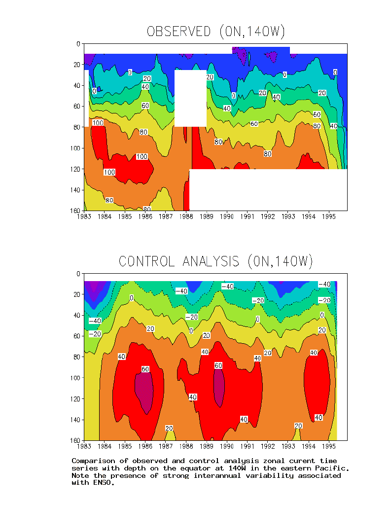
Equatorial Pacific moored current
The anomalous eastward surface velocity
at the equator during 1991 has corresponding subsurface changes. In Fig.
7 we compare observed current from the Tropical Ocean-Atmosphere
mooring maintained by the Pacific Marine Environmental Laboratory at ![]() .
At this longitude, close to the longitude of the section P17 shown in Fig.
5a the westward South Equatorial Current is confined to the upper
40 m where its annual average speed rarely exceeds -20 cm/s. During 1991
the South Equatorial Current shallows to 20 m and actually disappears early
in the year. The analysis velocity at the same longitude as the mooring
shows a significant westward bias (Fig. 7).
Thus, the South Equatorial Current is too strong and the Equatorial Undercurrent
velocity is too weak at this location, although the Undercurrent transport
is reasonable because the current spreads too far off the equator. The
surface South Equatorial Current is relatively weak during 1991, while
the Equatorial Undercurrent doesn't weaken until 1992. From these results
we conclude that better resolution is required to improve analysis of the
tropical currents.
.
At this longitude, close to the longitude of the section P17 shown in Fig.
5a the westward South Equatorial Current is confined to the upper
40 m where its annual average speed rarely exceeds -20 cm/s. During 1991
the South Equatorial Current shallows to 20 m and actually disappears early
in the year. The analysis velocity at the same longitude as the mooring
shows a significant westward bias (Fig. 7).
Thus, the South Equatorial Current is too strong and the Equatorial Undercurrent
velocity is too weak at this location, although the Undercurrent transport
is reasonable because the current spreads too far off the equator. The
surface South Equatorial Current is relatively weak during 1991, while
the Equatorial Undercurrent doesn't weaken until 1992. From these results
we conclude that better resolution is required to improve analysis of the
tropical currents.
In a companion to this study Carton et al. (1998) present a retrospective analysis of the temperature, salinity, and current of the upper ocean during the past five decades. The analysis system is complete in that it includes an ocean general circulation model, models of observation and forecast error, the basic hydrographic, altimeter, and SST data sets and a constraint algorithm. The historical data set is sufficiently limited that we have made no attempt to resolve midlatitude mesoscale variability and have limited our attention to the upper 500m of the water column.
In this study we present comparison to
a broad array of independent observations in order to identify features
of the analysis that appear to be capturing the historical interannual
and decadal variability of the ocean, and other features that seem unrealistic.
Comparison with island tide gauges suggests that the analysis explains
25% of the observed sea level variance at longer than annual frequencies,
and 31% in the frequency band between 5 and 25 years. Comparison to satellite
altimeter sea level shows a root-mean-square difference of 4.0 cm in the
tropics ![]() and 5.2 cm globally.
When altimetry is assimilated the root-mean-square difference in the tropical
sea level reduces to 3.1 cm.
and 5.2 cm globally.
When altimetry is assimilated the root-mean-square difference in the tropical
sea level reduces to 3.1 cm.
The structure of temperature and salinity
are examined by comparison to the ocean weather station S time series
in the subtropical North Atlantic and to a series of global hydrographic
sections. In both cases the results are encouraging. The comparison at
S shows that important features of the historical thermal record
are well reproduced, while features of the salinity record are reproduced,
although less successfully. Examples include the cooling and freshening
of the thermostaad between 200-400 m during 1972-4 and 1984-5. Comparison
to the transects in Table 3 show average
temperature and salinity errors in the upper 500m of ![]() and 0.092 psu. The temperature errors are mainly concentrated at thermocline
depths. Salinity errors are distributed through the mixed layer and pycnocline.
and 0.092 psu. The temperature errors are mainly concentrated at thermocline
depths. Salinity errors are distributed through the mixed layer and pycnocline.
It is equally interesting to identify those aspects of the analysis which are clearly inconsistent with the observations. Major problems include:
Despite these problems the authors feel greatly encouraged by the potential of the analysis for upper ocean climate studies on interannual to decadal time-scales.
Acknowledgments
We are very grateful to a number of people who have given us access to their data sets. Mark Swenson and Zengxi Zhou of the Atlantic Oceanographic Marine Laboratory have provided the monthly-averaged surface drifters, Sydney Levitus, and Robert Cheney and their colleagues at the National Oceanographic Data Center/NOAA have provided access to the hydrographic and altimeter data. We have benefited from the data sets collected by Principal Investigators of the Tropical Ocean/global Atmosphere World Oceanographic Circulation Experiments. Finally, we want to express our gratitude for support from the Office of Global Programs/NOAA under grant (NA66GP0269) and the National Science Foundation under grant (OCE9416894).
References
Bennett, A.F., 1990: Inverse methods in physical oceanography, Cambridge University Press, New York, 346pp.
Bloom, S.C. 1996: Data assimilation using incremental analysis updates, Mon. Wea. Rev., 124, 1256-1271.
Carton, J.A., G. Chepurin, X. Cao, and B.S. Giese, 1998: A Simple Ocean Data Assimilation analysis of the global ocean, 1950-1995, submitted.
Cheney, R.E., L. Miller, and J. Lillibridge, 1994: Topex/Poseidon, the 2 cm solution, J. Geophys. Res., 99, 24,555-.
Cooper, A., and K. Haines, 1996: Data assimilation with water property conservation. J. Geophys. Res., 101, 1059-1077.
da Silva, A. M., C. C. Young and S. Levitus, 1994: Atlas of Surface Marine Data 1994, Volume 1: Algorithms and Procedures. NOAA Atlas NESDIS 6, U.S. Department of Commerce, NOAA, NESDIS.
Daley, R., 1991: Atmospheric data analysis, Cambridge University Press, NY, 457pp.
Dee, R., and A.M. da Silva, 1996: Data assimilation in the presence of forecast bias. Submitted to Q. J. R. Met. Soc.
Dinsmore, R.P., 1996: Alpha, Bravo, Charlie, Oceanus, 39, 9-10.
Ji, M. A. Leetmaa, and J. Derber, 1995: An ocean analysis system for seasonal to interannual climate studies. Mon. Wea. Rev., 123, 460-481.
Joyce, T., and P. Robbins, 1996: the long-term hydrographic record at Bermuda, J. Clim., 9, 3121-3131.
Levitus, S., 1990: Interpentadal Variability of Steric Sea Level and Geopotential Thickness of the North Atlantic Ocean, 1970-1974 Versus 1955-1959. J. Geophys. Res., 95, 5233-
Levitus, S., T.P. Boyer, and J. Antonov, 1994: World Ocean Atlas, 1994, volume 5: Interannual variability of upper ocean thermal structure, NOAA, NESDIS, Atlas series, 176pp.
Malanotte-Rizzoli, P., 1996: Modern Approaches to Data Assimilation in Ocean Modeling, Elsevier, New York, 455pp.
Michaels, A.F., and A.H. Knap, 1996: Overview of the U.S. JGOFS Bermuda Atlantic time-series study and the Hydrostation S program, Deep-Sea Res., 43, 157-198.
Miller, R.N, and M. Cane, 1996: in Modern Approaches to Data Assimilation in Ocean Modeling, Elsevier, New York, 455pp
Mitchum, G., 1994: Comparison of TOPEX sea surface heights and tide gauge sea levels, J. Geophys. Res., 99, 24,541-.
Niiler, P., D. V. Hansen, D. Olson, P. Richardson, G. Reverdin, and G. Cresswell, 1997: The Pan Pacific surface current study, Lagrangian drifter measurements: 1988-1994. J. Phys. Oceanogr. (submitted).
Reynolds, R.W. and T.M. Smith, 1994: Improved global sea surface temperature analysis using optimum interpolation. J. Clim., 7, 929-948.
Roemmich, D., 1990: Sea level and the thermal variability of the ocean. "Sea-Level change", Geophysics study committee, Commission of Physical Sciences, Mathematics and Resources, National Research Council, National Academy Press, 208-217.
Talley, L.D., and M.E. Raymer, 1983: Eighteen degree water variability, J. Mar. Res., 40, 747-775.
Wunsch, C., 1996: The
ocean circulation inverse problem, Cambridge University Press, New
York, 442pp.
Figure Legends
Fig. 1 Observed and control analysis sea level time series at Kwajalein Island (9N, 168E). A linear trend has been removed from both records.
Fig. 2
Five year Low-pass filtered observed and control analysis sea level at
three locations: San Juan, Puerto Rico (![]() ),
Honolulu (
),
Honolulu (![]() ), and Kwajalein Island
(
), and Kwajalein Island
(![]() ).A linear trend has been removed
from all records.
).A linear trend has been removed
from all records.
Fig. 3 Observed and analysis temperature
and salinity at Ocean Weather Station S
(![]() ). Upper panel shows observations.
Second panel shows Expt. 6 analysis
without any salinity updating. Third panel shows control analysis which
includes a covariance model for the temperature and salinity errors, but
without using salinity observations. Bottom panel shows Expt.
5 analysis which includes salinity observations (except those at
S).
). Upper panel shows observations.
Second panel shows Expt. 6 analysis
without any salinity updating. Third panel shows control analysis which
includes a covariance model for the temperature and salinity errors, but
without using salinity observations. Bottom panel shows Expt.
5 analysis which includes salinity observations (except those at
S).
Fig. 4 Sea level error estimated using three years of Topex/Poseidon altimetry. a) Root-mean-square difference between altimeter and Expt. 7 analysis sea level in which altimeter sea level observations have been excluded from the analysis. b) Root-mean-square difference between altimeter and control analysis sea level in which temperature and salinity are constrained by altimeter observations.
Fig. 5 Temperature and salinity with depth along WOCE meridional transect P17 in the eastern Pacific Ocean during June-July, 1991. The observed transect was made of three separate sections. Upper panel shows the difference between observed and analysis, middle panel shows observations, lower panel shows analysis. a) Temperature, b) salinity.
Fig. 6 Comparison of anomalous observed and control analysis near-surface annual-averaged anomalous currents in the tropical Pacific during 1991. Upper panel shows currents based on drifter observations, while lower panel shows currents from the control analysis. Anomalous currents have been computed relative to the 1988-1993 monthly climatology. Observed and analysis tropical currents show a distinctive eastward anomaly during this year.
Fig. 7
Comparison of observed and control analysis zonal current time series on
the equator with depth at ![]() in
the eastern Pacific. Note the presence of strong interannual variability
associated with ENSO.
in
the eastern Pacific. Note the presence of strong interannual variability
associated with ENSO.